SARWind: The Smart Choice for Offshore Wind Resource Assessment

Maximize Your Offshore Wind Potential
with SARWind
SARWind delivers high resolution offshore wind data to alleviate the lack of large-scale measurements in offshore locations impacting all stages of a project life cycle.
Designed for offshore wind stakeholders, SARWind leverages satellite-based observations and advanced analytics to de-risk investments and optimize energy yield projections.
Why Choose SARWind?
Data-Driven Site Selection
Characterize and identify the best offshore locations with historical and high-resolution wind data
Proven Accuracy
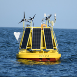
Validated against in-situ measurements (buoys, LiDARs, anemometers)
Seamless Integration
Compatible with wake models and wind resource assessment workflows
Expertise You Can Trust
20+ years of remote sensing experience
SARWind Solutions:
Tailored Insights for Every Development Phase
SARWind ATLAS & ATLAS+
SARWind ATLAS and ATLAS+ provide high-resolution, long-term wind statistics derived from satellite observations, helping developers make informed site selection decisions.
Spatial planning and risk assessment in early-stage development, ensuring a reliable and data-driven approach to offshore wind farm siting.
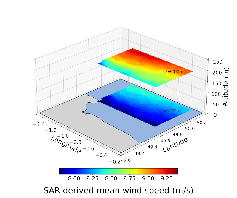
- SARWind ATLAS delivers wind data at 10 meters above sea level, offering precise insights into surface wind conditions.
- SARWind ATLAS+ extends this analysis up to 300 meters in altitude, enabling a detailed vertical wind profile critical for turbine height optimization.
Both products support spatial planning and risk mitigation, helping offshore wind developers reduce uncertainties before committing to costly on-site measurements.
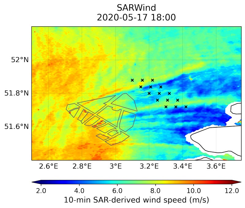
SARWind TIMESERIES
SARWind TIMESERIES offers long-term, high-frequency wind data, essential for offshore wind resource assessment studies. With wind speed, direction, and vertical shear recorded at one-hour intervals, this dataset provides reliable input for energy yield modeling and financing decisions.
Available at 10m above sea level and in altitude, SARWind TIMESERIES enhances bankability by ensuring developers have continuous, validated wind data at specific locations within lease areas.
It provides reliable wind data for informed investment and energy yield projections.
Technical Specifications:
SARWind's Data Processing & Capabilities
SARWind ATLAS & ATLAS+
High-resolution spatial planning and risk assessment
SARWind ATLAS and ATLAS+ leverage satellite-derived wind fields and advanced extrapolation techniques to provide reliable long-term wind statistics for offshore site selection.
Key Features
- Derivation of surface wind fields from SAR since Dec 2015, with vertical extrapolation
- Long-term mean wind speed with low-temporal sampling correction
- 500-m horizontal resolution
- Available at 10m above sea level and up to 300m altitude
Spatial Planning and Risk Mitigation
- Mean wind speed analysis
- Weibull distributions for wind energy characterization
- 2D wind maps for spatial analysis
- Data available at surface (10m) and at multiple altitudes
SARWind TIMESERIES
Long-term, high-frequency wind resource assessment
SARWind TIMESERIES provides validated, continuous wind data for offshore energy yield modeling, ensuring accuracy and compliance with industry standards.
Key Features
- Advanced Measure-Correlate-Predict (MCP) method, IEC compliant
- Spatial and long-term correction of ERA5 model
- Wind data derived from SAR observations, ensuring consistency
- Available globally in regions with good satellite coverage
Offshore Wind Resource Assessment with Time-Series
- Wind speed and direction data at 1-hour frequency
- Available for single points, clusters of points, or 2D spatial maps
- Data provided at 10m above sea level or at altitude
Key Applications with SARWind
SARWind provides flexible and high-resolution wind data solutions that support various offshore wind development needs. Whether used as a standalone tool or integrated with existing models, SARWind enhances site selection, energy yield predictions, and resource assessment accuracy.
- Standalone or coupled with a wake model to compute the annual energy production
- Global wind atlas at high resolution, allowing discrimination between different mesoscale models
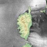
- Siting: focus and precision in areas with strong coastal effects
- Can complement LiDAR campaigns by optimizing LiDAR locations or extrapolating existing LiDAR data horizontally
The Science Behind SARWind:
How It Works
Cutting-Edge Satellite Observations
SARWind leverages Synthetic Aperture Radar (SAR) imagery from European satellites to directly observe air-sea interactions affecting offshore wind conditions:
- Wind-related effects: convective cells, atmospheric fronts, turbine wake effects.
- Non-wind factors: rain cells, ocean currents, sea surface films (biological, pollution).
Processed by Remote Sensing Experts
Since 2003, CLS has been developing a high-level expertise to retrieve geophysical information at sea surface level from SAR imagery, including wind, wave, and current products.
Advanced Data Processing & Validation
Our methodology is backed by 20 years of remote sensing expertise and validated against:
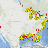
- 10m altitude data: 63 surface anemometers, 11,050 in-situ observations (US case study).
- Up to 300m altitude: 28 LiDARs and met masts, showing 1.9% absolute bias error (vs. 3.7% for high-resolution mesoscale models).
From Ocean Surface to Turbine Height: A Complete Data Chain
SAR processing dedicated to offshore wind
SAR Surface Imagery
through 2 European Satellites

Machine
Learning
Metocean Buoys
22,000 co-locations US ocean buoys
Vertical extrapolation up to 300m
Existing Lidars
+30 years, 12 lidars in North Sea
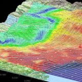
High-Resolution Atmospheric Model
Machine
Learning
Case Studies:
How SARWind Supports Offshore Wind Projects
France
National Wind Resource Assessment
- SARWind ATLAS+ (1km resolution) used by the French Directorate General for Energy & Climate
- Supported bidders for offshore wind tenders in Normandy & South Brittany
China
High-Resolution Wind Mapping
- SARWind ATLAS+ (500m resolution) deployed over 10,000 km² in Korea Bay
- Used by CSSC company in collaboration with Meteodyn China, a CLS Group subsidiary
USA
Offshore Bat Monitoring & Wind Farm Development
- SARWind ATLAS+ & TIMESERIES used in a US Department of Energy project
- Collaboration with EPRI, BOEM & Woods Hole Group, our american subsidiary, for high-resolution geophysical data
Get Started with SARWind Today
Ready to optimize your offshore wind project with high-resolution wind intelligence?
Contact us now to discuss your project and get a demo of SARWind!
