
Improving Wind Resource Assessment in Highly Forested Areas with CFD Calibration
- October 20, 2026
- Category: News
Forests have a strong influence on wind flow. For wind farm developers, this creates specific challenges when seeking high accuracy in wind speed simulations in highly forested areas.
To address this challenge, Meteodyn and EDF Power Solutions have developed a CFD forest calibration methodology within Meteodyn WT. Investigated through a project conducted with EDF Renewables, the methodology uses wind speed profile measurements to adapt the CFD forest model to real forest properties.
The approach was investigated across six calibration and cross-prediction cases at three international sites, and the results were published in the peer-reviewed journal Energies by MDPI.
Why do forests matter for Wind Resource Assessment?
Surface characteristics strongly influence wind flow.
Meteodyn WT uses Computational Fluid Dynamics (CFD) to account for heterogeneous roughness elements such as forests, crops and built areas. The software is designed to simulate wind flow across environments ranging from coastlines and flat terrain to forests and mountainous areas.
In highly forested areas, the representation of the forest itself therefore becomes an important part of wind flow modelling.
The methodology investigated by Meteodyn focuses specifically on improving this representation by using measured wind profiles to calibrate the CFD forest model.
The objective is clear: select the model parameters that allow the simulated wind profile to be as close as possible to the measured profile.
How does the CFD forest calibration methodology work?
The methodology is based on wind speed profile measurements.
These measurements are used to adapt the CFD forest model to the actual forest properties considered at the site.
In Meteodyn WT, the forest model is mainly described through two parameters:
- Tree height, defined using roughness length values and the ratio between tree height and roughness length.
- Forest density, which directly affects the drag-force term associated with the forest effect.
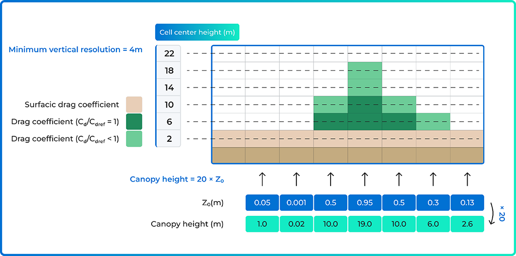
The calibration process consists in adjusting these parameters and comparing the resulting CFD wind profile with the measured profile to identify the configuration providing the closest representation.
This methodology builds on Meteodyn WT’s CFD capabilities for modelling heterogeneous roughness, including forests, and their impact on wind flow.
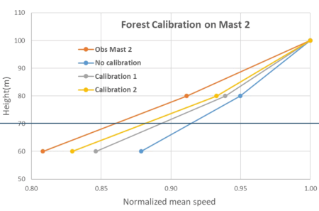
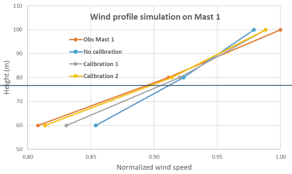
Comparison between the observed wind profile and different CFD forest calibration configurations.
A methodology investigated across three forested sites
To assess the methodology, six calibration and cross-prediction cases at three forested sites were investigated using Meteodyn WT.
Each site included two meteorological masts, with common measurement periods and heights and heterogeneous forest cover. The distance between the two masts ranged from 2 to 6.6 km.
Two different land cover maps were used to match the measurement period and in situ observations as closely as possible. For sites 2 and 3, Corine Land Cover (CLC) roughness maps were chosen, while for Site 1, a Copernicus Land Cover (LC) roughness map was used.
For the representative case detailed in the study, several forest calibration configurations were compared.
The results showed that modifying roughness and/or forest density affects the simulated vertical wind profile. When these parameters increase, the study generally observed a reduction in wind speed at lower heights and an increase above.
What results were obtained?
Cross-validation was performed to evaluate the forest calibration methodology for horizontal extrapolation.
The results showed:
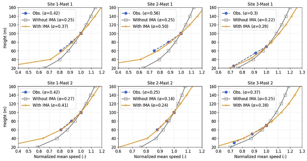
- Shear differences between simulations and measurements were reduced significantly from [0.08–0.3] to [0.01–0.07]
- Horizontal mean speed errors have been reduced from [1.0–9.5%] to [0.5–2.2%]
- A global mean absolute speed error of 1.1% based on six cases
The study also highlighted that the influence of forest model calibration was observed not only at low heights but also above, close to wind turbine hub heights.
Based on these results, the study recommends using the new calibration approach for wind farms located in forested areas.
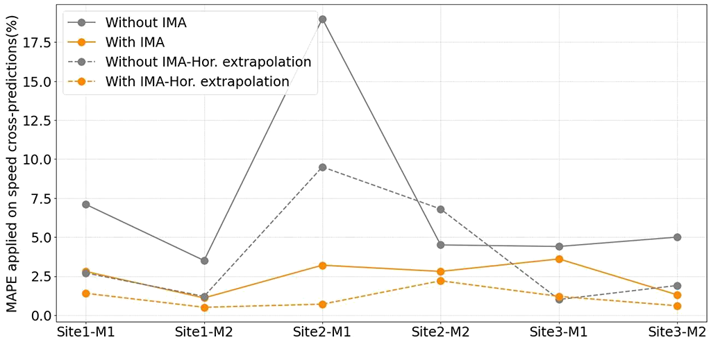
Influence of IMA methodology on Mean Absolute Percentage Errors applied on cross-predicted wind speed values. For each site, cross-predicted wind speed values are simulated using the other mast as a reference. It means that M1 is used as a reference mast to estimate M2 and M2 is used as reference mast to estimate M1.
Understanding the scope of the methodology
The webinar provides additional information on how the methodology should be applied.
During the Q&A, Meteodyn explains that the forest calibration approach is dedicated to moderately complex sites. On very complex terrain, wind flow can be mainly influenced by orography.
For forest calibration, similar conditions are also assumed between the meteorological mast and the wind turbines.
Some aspects remain under investigation. Meteodyn states in the webinar that the influence of forest calibration on turbulence is still being studied.
The study was also conducted on projects based on pine forests. Seasonal effects were therefore low in these cases, while Meteodyn identifies the investigation of other tree types as an interesting area for further study.
These points define the scope of the methodology and the conditions in which its results should be interpreted.
Meteodyn WT: CFD modelling for Wind Resource Assessment
The forest calibration methodology is implemented within Meteodyn WT, Meteodyn’s CFD software for numerical wind simulation and Wind Resource Assessment.
Meteodyn WT generates Wind Resource Grids, wind resource maps and detailed 3D wind field computations, providing a spatial representation of the wind resource. It also models wake effects and calculates Annual Energy Production while considering wake effects, atmospheric stability and turbulence.
The software also provides wind characteristics at future turbine locations to support turbine class selection in accordance with the requirements of IEC 61400-1.
For highly forested sites, the new calibration methodology provides a way to refine the CFD representation of forest properties using measured wind profiles.