
Reducing geotechnical uncertainty before construction with historical satellite InSAR
- July 9, 2026
- Category: News
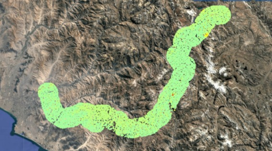
Seven years of Sentinel-1 observations were processed to evaluate historical ground deformation along the future highway alignment.
CASE STUDY — Carretera Central
📏 185 km transport corridor
🏔 36 km of tunnels
🌉 19 km of bridges & viaducts
🛰 Sentinel-1 archive (2015–2022)
Designing major transport infrastructure through mountainous terrain is as much a geological challenge as an engineering one. While topographic surveys and geotechnical investigations provide essential information on ground conditions, they capture only a snapshot of the terrain at a given point in time. Yet many geohazards develop progressively over years or even decades, making their historical behavior just as important as their current state.
For project owners and engineering teams, this raises a fundamental question long before the first excavation begins: has the ground remained stable over time, or is it already showing signs of slow deformation that could compromise the future infrastructure?
Historical satellite InSAR addresses this challenge by adding a temporal dimension to conventional site investigations. By analyzing years of radar satellite observations, engineers can reconstruct ground motion across entire infrastructure corridors, identify unstable slopes and reduce geotechnical uncertainty during the earliest stages of project development.
The Carretera Central project in Peru provides a compelling example of how archived satellite observations can support better engineering decisions before construction even begins.
Beyond the surface: Why static terrain data is no longer enough
Traditional geotechnical investigations remain indispensable for infrastructure design. Boreholes, laboratory testing, GNSS surveys and field inspections provide highly accurate local measurements that are essential for characterizing ground conditions. However, these techniques cannot reveal how the terrain has evolved over time across an entire infrastructure corridor extending over hundreds of kilometers.
Historical satellite InSAR complements these investigations by transforming years of satellite observations into actionable engineering intelligence. This enables project teams to make better-informed decisions from the earliest stages of infrastructure planning. Using archived Sentinel-1 radar imagery acquired over several years, TRE ALTAMIRA applies its patented SqueeSAR® processing technology to measure millimetric ground deformation over very large areas.
Unlike conventional Persistent Scatterer approaches, SqueeSAR® exploits both Persistent Scatterers (PS) and Distributed Scatterers (DS), significantly increasing measurement density over natural terrain such as rocky slopes, bare soil and sparsely vegetated mountain environments. The result is a detailed historical displacement map capable of revealing slow-moving instabilities that may otherwise remain undetected during conventional site investigations.
Rather than replacing field measurements, satellite InSAR helps engineers determine where detailed investigations should be prioritized, reducing uncertainty before critical design decisions are made.
A strategic transport corridor through the Peruvian Andes
This methodology was applied during the feasibility phase of Peru’s New Carretera Central, officially known as the Daniel Alcides Carrión Highway.
Representing an investment exceeding US$6.5 billion, the new 185-kilometre highway will connect Metropolitan Lima to Peru’s central highlands while reducing travel times by nearly 50%. The project includes four traffic lanes, 36 kilometers of tunnels and 19 kilometers of bridges and viaducts crossing one of the country’s most geologically complex mountain regions.
Such an ambitious linear infrastructure project requires a comprehensive understanding of terrain stability long before construction begins. Even localized slope instabilities can have significant consequences for design optimization, construction safety and long-term infrastructure resilience.
To support the route assessment, TRE ALTAMIRA analyzed seven years of Sentinel-1 SAR acquisitions, covering the period from 2015 to 2022. The objective was to evaluate the historical behavior of the terrain and identify areas potentially affected by slow-moving landslides.
Discover our satellite ground deformation monitoring capabilities
Learn how CLS and TRE ALTAMIRA help infrastructure owners detect millimetric ground deformation, assess geohazards and support engineering decisions throughout the asset lifecycle.
Spotting the red flags: Detecting slope instability before excavation
The satellite analysis first provided engineers with a regional overview of ground stability across the entire planned corridor. This large-scale screening rapidly highlighted several areas exhibiting measurable deformation.
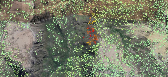
Focus on a critical area (the red spot). © TRE ALTAMIRA. SAR source image: Contains modified Copernicus Sentinel data 2015-2022.
Engineers could then focus on these locations to better understand the underlying geological processes and prioritize complementary geotechnical investigations.
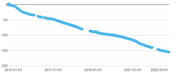
One particularly critical sector exhibited continuous cumulative displacement throughout the seven-year observation period. Rather than reflecting an isolated event, the associated displacement time series demonstrated a persistent deformation process developing over several years, providing valuable evidence for evaluating long-term slope stability before construction activities commenced.
This historical perspective allows engineering teams to anticipate potential geohazards earlier in the project lifecycle, optimize mitigation strategies and reduce design uncertainty before significant investments are committed.
Integrating historical Earth observation into infrastructure engineering
As transport, energy and mining infrastructure projects continue to expand into increasingly challenging environments, historical Earth observation is becoming an integral component of modern engineering workflows.
Satellite InSAR offers a non-invasive, cost-effective means of screening extensive territories before field deployment, helping engineering teams identify areas requiring further investigation while optimizing survey campaigns and reducing unnecessary site interventions.
Beyond the planning phase, historical deformation analyses also establish a valuable baseline for future monitoring programs, allowing asset owners to compare pre-construction, construction and operational ground behavior using a consistent measurement framework.
Through its partnership with TRE ALTAMIRA, CLS combines advanced satellite analytics with engineering expertise to transform years of archived SAR observations into actionable geotechnical intelligence, supporting infrastructure developers throughout the entire asset lifecycle.
Planning a transport or energy infrastructure project?
Whether you are assessing a future transport corridor, pipeline, mining operation or energy infrastructure, our experts can help you integrate historical satellite InSAR into your engineering workflow.