Autonomous Offshore Ocean Current Monitoring: 38 Days and 4,000 Nautical Miles with FAST Eddy USV
- October 28, 2026
- Category: News
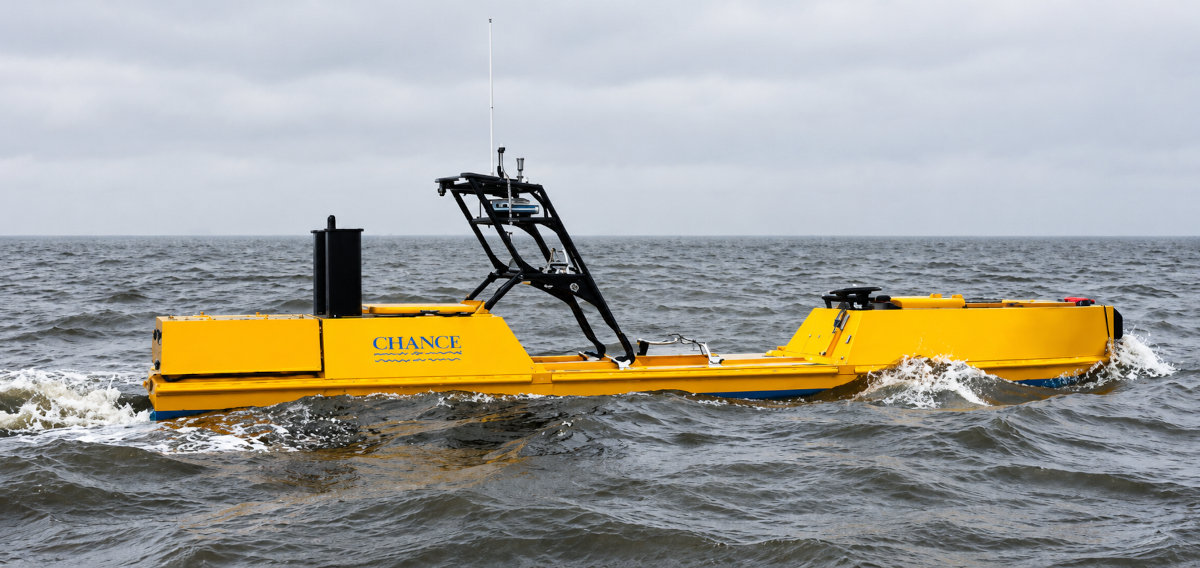
38 days. More than 4,000 nautical miles. Up to 200 nautical miles offshore. No crew onboard, no refuelingrefueling, and no support vessel.
Woods Hole Group, a CLS company, and Chance Maritime Technologies successfully completed an uninterrupted 38-day FAST Eddy Loop Current monitoring survey in the U.S. Gulf using a Chance Maritime MC40 Unmanned Surface Vessel (USV).
Operating up to 200 nautical miles offshore, the vessel continuously collected and transmitted near-real-time ocean current data while completing more than 4,000 nautical miles without stopping, refueling or requiring physical offshore intervention.
Beyond the endurance milestone, the mission demonstrates how autonomous platforms, in-situ measurements, satellite connectivityconnectivity, and expert oceanographic analysis can be integrated to support safer and more efficient offshore operations.
FAST Eddy USV: an integrated autonomous metocean monitoring system
The mission combined Woods Hole Group’s FAST Eddy – Fast Autonomous Survey Technology – system with Chance Maritime’s 40-foot / 12 m MC40 Unmanned Surface Vessel.
FAST Eddy continuously collects, processes and transmits ocean current data via satellite modem to Woods Hole Group’s servers. The information is displayed through the secure Metocean Mapper GIS portal and can then be accessed and interpreted by Woods Hole Group oceanographers.
The complete monitoring chain combines:
In-situ measurements → onboard processing → satellite transmission → visualization → oceanographic analysis → operational intelligence

38 days
Uninterrupted offshore operation

4,000+ NM
Distance travelled

200 NM
Maximum offshore distance

8
FAR Horizon drifters deployed

24/7
Remote operational oversight

75 kHz + 300 kHz
ADCP measurements

12+ ft
Sea conditions encountered
Profiling ocean currents with dual-frequency ADCPs
FAST Eddy integrates 75 kHz and 300 kHz Acoustic Doppler Current Profilers (ADCPs) to provide near-real-time current profile measurements throughout the deployment.
Unlike a single surface measurement, ADCP profiling provides information on how current velocity and direction vary through the water column.
This vertical current structure is particularly valuable for offshore activities involving vessels, subsea infrastructure, installation operationsoperations, and equipment exposed to strong current regimes.
During the campaign, measurements were continuously transmitted via satellite for remote access and interpretation.
From measurements to operational intelligence with EddyWatch®
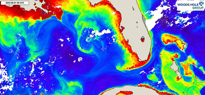
FAST Eddy measurements also contribute to Woods Hole Group’s EddyWatch® ocean current intelligence service, developed to support offshore operations in areas affected by strong currents.
EddyWatch combines multiple sources of oceanographic information:
• satellite-tracked drifting buoys;
• advanced satellite remote sensing;
• in-situ observations;
• ocean forecast models;
• FAST Eddy measurements;
• expert oceanographic analysis.
Together, these inputs support current nowcasts, forecasts, and early warning of changes in Loop Current and Loop Current Eddy conditions.
The objective is not simply to provide more data.
It is to transform multiple observations into actionable ocean current intelligence that helps offshore operators improve planning, enhance operational safetysafety, and minimize downtime.
Autonomous deployment of drifting buoys
The MC40 was also equipped with a dedicated payload enabling the autonomous deployment of Woods Hole Group FAR Horizon drifting buoys at client-defined locations.
During the 38-day mission, the vessel successfully deployed eight drifters while continuing its ocean current monitoring activities.
According to the FAST Eddy USV specification, the platform can carry and deploy up to 18 FAR Horizon drifters.
The combination of vessel-mounted ADCP measurements and satellite-tracked drifters provides complementary information on both the vertical structure of ocean currents and the movement of water masses across the survey area.
During the mission, the MC40 autonomously deployed eight FAR Horizon drifting buoys at predefined locations.
Long-endurance monitoring in demanding offshore conditions
For 38 consecutive days, the MC40 operated with no crew onboard, no refueling, no support vesselvessel, and no physical offshore intervention.
The vessel travelled more than 4,000 nautical miles, demonstrating the potential of autonomous systems for persistent offshore monitoring.
During the campaign, the MC40 encountered gale-force winds and seas exceeding 12 feet, while maintaining approximately 4.5 knots.
Its continuous diesel propulsion provides high payload capacity, full maneuverability and consistent survey speed, while an active gyrostabilizer supports offshore seakeeping.
The system is designed for continuous surveys of up to approximately 40 days and a 4,000-nautical-mile range, with survey speeds of approximately 4.5 to 6 knots.
Autonomous offshore operations with 24/7 shore-based control
Autonomous does not mean unattended.
Throughout the project, Chance Maritime’s operators maintained 24/7 operational oversight from shore.
Remote operators had access to:
• live-streaming video;
• radar;
• AIS;
• marine VHF radio.
These systems provided continuous situational awareness throughout the mission.
This combination of autonomous vessel capability and shore-based supervision enables extended unmanned offshore operations while maintaining continuous operational control.

A lower-footprint alternative for offshore current surveys
The MC40 was specifically designed for ocean current surveys traditionally conducted using larger crewed vessels.
According to the FAST Eddy USV technical documentation, the vessel can survey at speeds and under operating conditions comparable with a typical Offshore Supply Vessel.
For suitable missions, the autonomous platform can reduce several operational constraints associated with crewed offshore surveys, including crew rotations, personnel exposure offshore and interruptions linked to vessel operations.
Its smaller platform also significantly reduces fuel requirements.
According to the FAST Eddy USV specification, an OSV can consume more fuel in one day than the MC40 consumes during 40 days of operation.
For offshore energy operators, this creates an opportunity to combine persistent oceanographic monitoring with reduced personnel exposure and a lower operational carbon footprint.
From autonomous monitoring to offshore decision support
The significance of this 38-day mission goes beyond an endurance record.
It demonstrates an integrated approach combining:
autonomous platforms + in-situ sensors + satellite connectivity + remote operations + data platforms + forecasting models + expert oceanographic analysis.
FAST Eddy provides the measurements.
Metocean Mapper provides access to the data.
EddyWatch® adds forecasting and expert interpretation.
Together, they provide offshore operators with continuously updated ocean current intelligence to support operational decision-making.
The 38-day, 4,000-nautical-mile campaign provides concrete evidence that long-duration autonomous ocean current monitoring is becoming an operational offshore capability.
Need reliable ocean current intelligence for your offshore operations?
Woods Hole Group supports offshore energy operators with FAST Eddy, EddyWatch®, autonomous monitoring and expert metocean services to better understand changing ocean conditions and support safer, more efficient operations.